PRF Highlights
In 2019, CCBWQA contributed over $585,000 towards restoration of almost 4,100 lineal feet of streams in the basin. $8.4 million of Pollution Abatement Project development, operations and maintenance budget is included in the Authority 10 year Capital Improvement Plan.
In 2019 work was performed on 3 key Pollution Reduction Facilities:
McMurdo Gulch Reaches 7, 11, 12, 14, and 15
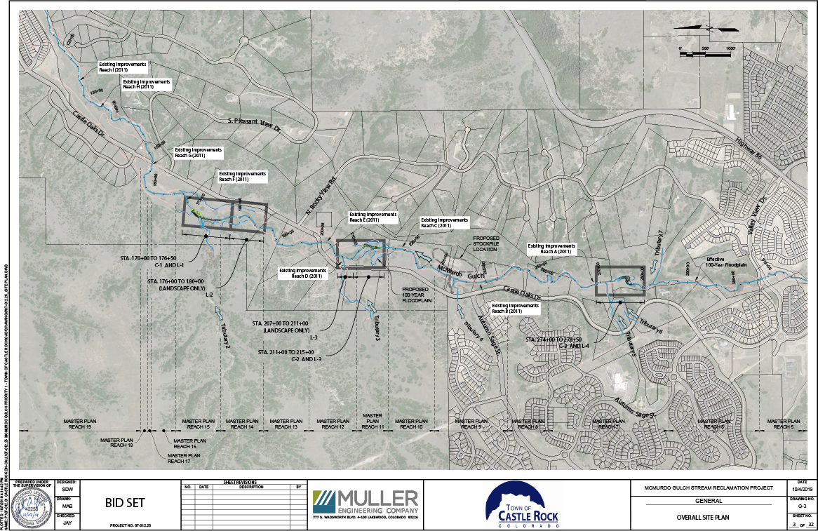
Click on the map to see an enlarged version
The McMurdo Gulch Reaches 7, 11, 12, 14, and 15 extend the previous stream improvements constructed in 2011. The stream improvements are being phased in as development occurs and in response to the stream’s reaction. This approach prevents severe degradation and erosion. This project stabilizes the stream and reduces impacts to water quality through grade control using riffle and cascade drop structures, bank protection, and seeding and plantings to connect with the gulch’s water table.
This project repairs erosion, prevents severe degradation, and provides sediment transportation that is in balance. The McMurdo Gulch project enhances the aquatic, wetland, and riparian functions of the gulch while protecting water quality.
The design of this project is complete, and construction is scheduled for 2020.
Cherry Creek at KOA
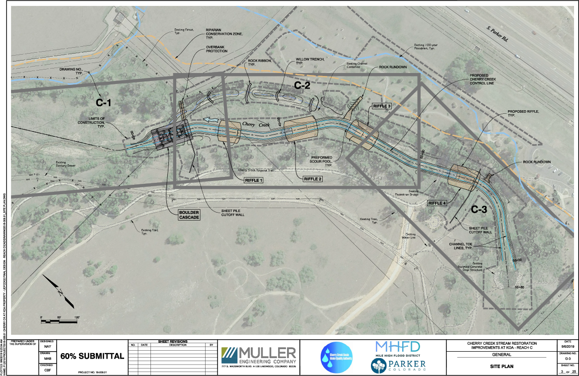
Click on the map to see an enlarged version
The Cherry Creek at KOA project has degraded due to an increase in urbanization, and the rate, frequency, duration and magnitude of stormwater runoff. These effects have accelerated the degradation of the streambed and banks resulting in the loss of wetlands and upland vegetation.
This project raises the streambed and re-establishes the water table to prevent further loss of vegetation and down-cutting, erosion, and sediment transport issues. The overall project goals are to restore and enhance the aquatic, wetland, and riparian functions Cherry Creek and immobilize nutrients in the stream banks to improve water quality.
The design of this project is 60% complete, and construction is scheduled for Fall of 2020 through Summer of 2021.
Cherry Creek at 12-mile Park Phase III
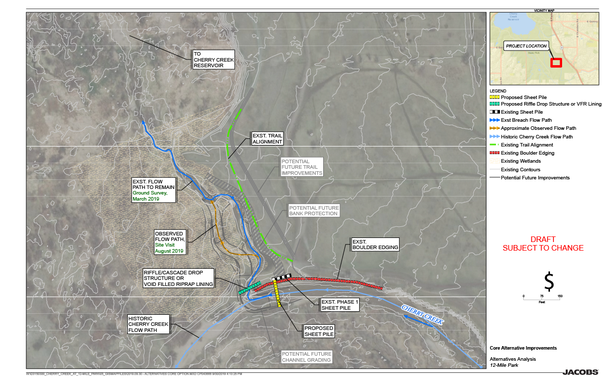
Click on the map to see an enlarged version
The Cherry Creek 12-mile Park Phase III project continues the work completed in 2012 and 2014. This project protects infrastructure that was built in the previous phases and provides a transition to the new flow path taken by Cherry Creek in 2017. The goal is to minimize stream degradation and while letting it take its own course. Bank protection is planned where the creek threatens to compromise existing trails and roads. The overall project goals are to allow the stream to move where it wants, minimize the degradation of stream bed and bank, and protect existing trails and roads, enhance and restore the wetland and riparian vegetation, and improve water quality.
The design of this project is 30% complete, and initial construction is anticipated in 2020 to protect the previous phases, and future construction as needed to meet the project goals.